The name Diez Vistas means “ten views”, but anyone who has hiked the trail knows that finding ten clear viewpoints is not quite as simple as the name suggests.
Some of the original vistas have gradually become obscured by tree growth, while other excellent viewpoints were never part of the original numbered vistas at all. Trees grow, openings change, and a viewpoint that was wide open years ago may eventually become only a glimpse through the forest.
I originally created this page in 2014 as my attempt to solve that problem. I called my version “Nuevo Diez Vistas” and put together an alternate set of ten viewpoints that, at the time, provided ten genuinely worthwhile views along the route.
The exact views have continued to change over the years, but the basic idea still works: there are more good viewpoints on and around Diez Vistas than the original numbered vistas alone would suggest.
Looking for the complete hike guide? See my Diez Vistas Trail guide for the full route description, trail statistics, GPS map, and hiking information.
This is my own unofficial viewpoint system, not BC Hydro’s official numbering. Tree growth, fallen trees, vegetation, and trail conditions can change the quality and visibility of individual viewpoints over time.
What Happened to the Ten Views?
When I first put this page together, I regularly heard the same comment from hikers: “Diez Vistas was a great hike, but I only found three or four of the vistas.”
Part of the problem is simply that several of the original viewpoints have become increasingly obstructed by trees. Apparently, the trees did not get the memo that they were supposed to preserve the views.
At the same time, there are several excellent viewpoints near the south end of Buntzen Ridge that were never included among the original numbered vistas.
These include the first open viewpoint reached during the climb, several viewpoints around the East Point area, and another good opening farther along the ridge.
The East Point Area
One of the easiest ways to miss some good scenery is to stay strictly on the main Diez Vistas route near the south end of the ridge.
The East Point area contains several additional viewpoints, including Punta Aprecio and Punta del Este, along with views toward Buntzen Lake, South Beach, Eagle Ridge, Burrard Inlet, and Indian Arm.
When I originally mapped the area, signage at the junction was poor and many hikers simply continued along the main trail without realizing that these additional viewpoints were nearby.
That was one of the reasons I thought an alternate set of ten viewpoints made more sense than trying to rely exclusively on the original vista numbering.
My Alternate Ten-View Idea
Rather than trying to force hikers to locate every original vista, my approach was to count the viewpoints that actually provided worthwhile views.
When I originally mapped the route, several of the original vistas still provided useful views, while other excellent openings were not part of the original numbered system. Together, these gave me a practical set of ten views that better matched the name of the trail.
I still liked the existing Spanish place names, such as Punta Aprecio and Punta del Este. My idea was simply to add clearer viewpoint numbering and better signage showing the East Point route and bypass.
I called the concept “Nuevo Diez Vistas” at the time. I still like the name, but today I think of it more simply as an alternate way of finding ten good views on Diez Vistas.
Diez Vistas GPS Route
The interactive map below shows one of my actual GPS recordings of the Diez Vistas hike. Use the layer control in the upper-right corner to switch between the regular map and satellite imagery.
My 2014 Viewpoint Maps
When I originally created this post in 2014, I made the following two maps showing my proposed viewpoint arrangement. These are not official BC Hydro maps, and the quality of individual views may have changed considerably since then.
Click either image for a larger version.
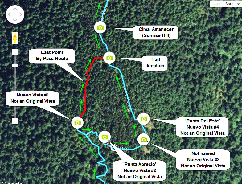
My 2014 map of the East Point area and its additional viewpoints.
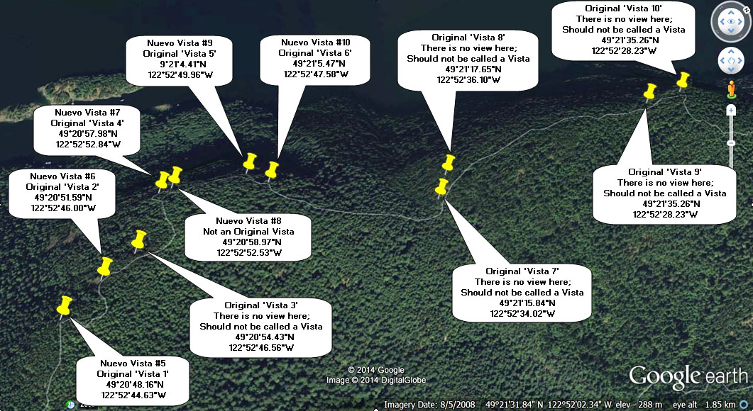
My proposed alternate Diez Vistas viewpoint numbering from 2014.
So, Are There Really Ten Views?
Yes, but I would not think of Diez Vistas as ten permanently fixed windows through the forest.
The number of genuinely open viewpoints changes over time. Some of the original views have become obscured, while other openings provide views that were never part of the original numbering. Fallen trees can create new views, while growing vegetation gradually closes others.
If your goal is simply to locate ten numbered signs or ten original openings, you may be disappointed. If your goal is to hike Buntzen Ridge and look for the best views available along the way, there is still plenty to see.
Clockwise Is Still My Preferred Direction
I prefer hiking Diez Vistas clockwise, tackling the steep southern climb and switchbacks first while I have the most energy. It also means reaching the southern viewpoints relatively early in the hike rather than saving them until near the end.
For the complete route description, trail statistics, and current hiking information, see my Diez Vistas Trail guide.
If you are driving to Buntzen Lake during the seasonal reservation period, also check the current Buntzen Lake parking information before leaving home.
For current trail closures and official access information, check the BC Hydro Buntzen Lake trails page.
The GPS route and viewpoint information on this page reflect conditions when I completed these hikes. Trails, vegetation, viewpoints, closures, and access can change over time. Follow current onsite signage and check current conditions before heading out.