St. Mark’s Summit is one of my favourite hikes on Vancouver’s North Shore, offering spectacular views of Howe Sound, its islands, and the surrounding mountains. Starting from the Cypress Mountain parking area in West Vancouver, the route follows the famous Howe Sound Crest Trail through beautiful subalpine forest before reaching a series of rocky viewpoints high above the water.
St. Mark’s Summit Trail Stats
🥾 Distance: 10.3 km return (my original recorded distance)
⛰️ Lowest elevation: 917 m
🏔️ Highest recorded elevation: 1,344 m
📈 Elevation difference: 427 m (lowest to highest; cumulative climbing is greater)
💪 Difficulty: Moderate to challenging in snow-free conditions
🔄 Route type: Out and back via the Howe Sound Crest Trail
🌲 Park: Cypress Provincial Park, West Vancouver, BC
📍 Trailhead: Cypress Mountain, Howe Sound Crest Trail access (Google Maps)
These are my original hiking statistics. The uploaded GPX track measures approximately 10.15 km and records elevations of 917 to 1,344 m. Different GPS recordings and routes to the viewpoints may produce different measurements.
St. Mark’s Summit GPS Route Map
The interactive map below shows my original GPS track from the Cypress Mountain parking area to St. Mark’s Summit and back. You can zoom in, move around the map, and switch between standard Map and Satellite views.
GPS route recorded during my original hike. The blue line includes the return journey. It is a historical track, not a guarantee of current trail alignment or conditions. Always carry a current map and appropriate navigation equipment.
Hiking to St. Mark’s Summit
Starting at Cypress Mountain
My hike began at the Cypress Mountain downhill ski area, where the Howe Sound Crest Trail heads north into Cypress Provincial Park.
The beginning of the route passes through the Cypress Bowl area before continuing into a beautiful forest of mountain hemlock, yellow-cedar, and other coastal mountain trees.
The first part of the hike is relatively gentle compared with the steeper sections farther along. Much of the trail follows a rolling route through forest and subalpine terrain, with occasional openings and small meadows.
Follow the marked Howe Sound Crest Trail towards St. Mark’s Summit. There are other trails in the Cypress Bowl area, including the route towards Bowen Lookout, so pay attention to signs at junctions.
Through the Forest
As you continue north, the trail becomes rougher, with exposed roots, rocks, muddy sections, and several short climbs and descents.
BC Parks describes the Howe Sound Crest Trail as difficult and rough beyond approximately the first 2 km. Although St. Mark’s Summit is a popular day-hiking destination, the route should not be mistaken for an easy walk.
One thing worth remembering is that the trail isn’t a continuous climb. There are several rolling sections, meaning the total elevation climbed over the hike is greater than the difference between the lowest and highest elevations.
The surrounding forest is particularly interesting. At these elevations, the growing season is relatively short, and snow can remain well into summer. Mountain hemlock and yellow-cedar thrive in this cool, wet environment.
The Final Climb and Summit Viewpoints
The final approach to St. Mark’s Summit becomes steeper and more demanding. Expect roots, uneven rock, and sections where you may need to watch your footing carefully.
Eventually, the forest opens onto rocky viewpoints overlooking Howe Sound.
This is the reward for all that climbing!
From the summit area, you can enjoy magnificent views across Howe Sound towards its forested islands and the mountains along the Sea-to-Sky corridor. On clear days, the combination of deep blue water, steep forested slopes, and distant peaks is outstanding.
Here is one of my photographs from the top.
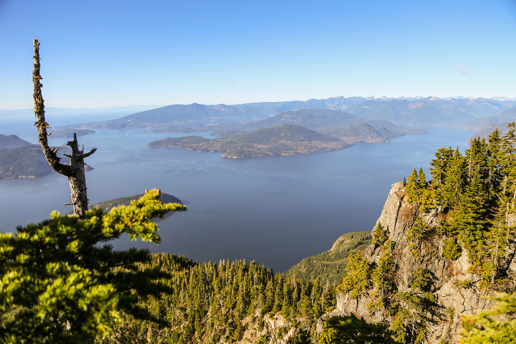
The spectacular view of Howe Sound from St. Mark’s Summit.
And here’s a photograph of me sitting on a rocky ledge overlooking Howe Sound. I couldn’t resist the opportunity for a dramatic photograph!
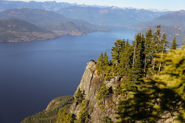
Me on a ledge at St. Mark’s Summit. King of the world!
The viewpoints are spectacular, but there are some very steep drop-offs. Keep well back from exposed edges, particularly when the rock is wet, icy, or covered by snow.
Views of the Lions
Another highlight of the hike was the view of the Lions, two prominent peaks that are among the most recognizable mountains on Vancouver’s North Shore.
They lie farther north along the Howe Sound Crest Trail, beyond St. Mark’s Summit and Unnecessary Mountain.
The Lions look particularly impressive from this part of the trail.
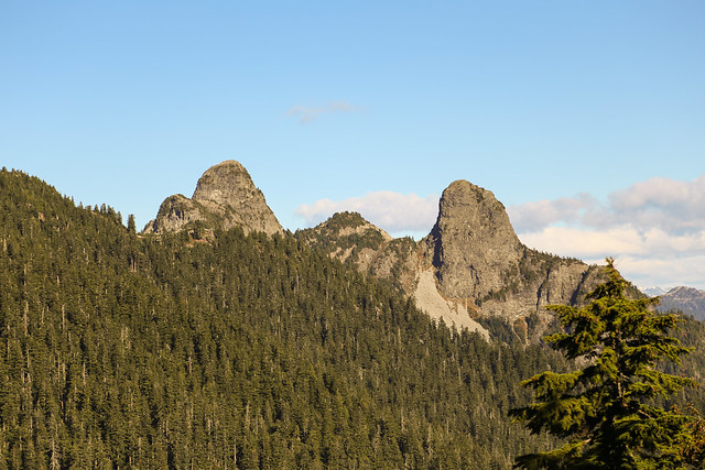
A great view of the Lions from the St. Mark’s Summit area.
The Howe Sound Crest Trail continues towards the Lions and beyond, but that is a considerably more demanding backcountry route. For this hike, I turned around at St. Mark’s Summit and followed the same trail back to Cypress Mountain.
Wildlife: The Whiskey Jacks
One of the most memorable parts of my hike was the number of Whiskey Jacks flying around the summit area.
These curious birds are also known as Canada Jays, and were previously commonly called Gray Jays. They are remarkably comfortable around people, especially in areas frequently visited by hikers.

One of the many Whiskey Jacks I encountered during the hike.
Canada Jays are fascinating birds. Unlike many other songbirds, they remain in their mountain forest habitat throughout the winter.
They survive partly by storing food in numerous hiding places during times when food is plentiful. Their remarkable ability to cache and recover food helps them survive long, cold winters.
They may approach hikers in search of a snack, but please don’t feed them. Human food can interfere with their natural feeding behaviour and encourages them to associate people with food.
Interesting Facts About St. Mark’s Summit
- Part of the Howe Sound Crest Trail: St. Mark’s Summit is located along the approximately 29 km Howe Sound Crest Trail, which runs north from Cypress Mountain through rugged mountain terrain towards the Porteau Cove area. St. Mark’s Summit is a popular turnaround point for day hikers.
- Cypress Provincial Park was established in 1975: The park protects an extensive area of the North Shore Mountains. The Howe Sound Crest Trail was added to the park in 1982.
- Howe Sound is a glacially carved fjord: During the last ice age, glaciers helped shape the deep valley and steep surrounding mountains. The resulting landscape provides some of the spectacular scenery visible from St. Mark’s Summit.
- Biogeoclimatic Zone: Cypress Provincial Park includes the Coastal Western Hemlock and Mountain Hemlock biogeoclimatic zones. The higher-elevation forests around St. Mark’s Summit are characteristic of the Mountain Hemlock Zone, with long-lasting snow, cool temperatures, mountain hemlock, yellow-cedar, and amabilis fir.
- Snow can remain into summer: Even when the weather is warm in Vancouver, substantial snow patches may remain along the higher sections of the trail. Depending on the winter snowpack and spring temperatures, these conditions can persist into July.
- Whiskey Jacks are year-round residents: Canada Jays remain in the mountains throughout the winter, relying partly on food stored in the surrounding forest.
- The summit has multiple viewpoints: Visitors can explore several rocky openings near the summit area, although caution is necessary because of steep exposed drop-offs.
- Popular but still backcountry terrain: Despite its popularity and proximity to Cypress Mountain, this is a mountain route with variable weather, uneven terrain, and limited or unreliable mobile reception.
Best Time to Hike St. Mark’s Summit
For most hikers, the best time to visit St. Mark’s Summit is during the snow-free summer and early autumn months, typically from July through September and sometimes into October, depending on conditions.
However, the timing varies considerably from year to year.
A heavy winter snowpack can leave significant snow along the trail well into early summer. Shaded forest sections and north-facing terrain can hold snow much longer than exposed areas.
Snow can obscure the trail, cover markers, and create dangerous conditions near steep slopes and viewpoints.
Winter travel: BC Parks strongly discourages winter travel along the Howe Sound Crest Trail beyond Bowen Lookout, which includes the route to St. Mark’s Summit. The hazards include avalanche terrain, difficult route-finding, and potentially severe mountain weather.
Even during the summer, it is worth checking the mountain forecast carefully. Conditions around 1,300 to 1,400 m can be very different from those in downtown Vancouver.
Hiking Preparation: The Ten Essentials
St. Mark’s Summit is a substantial mountain hike, so proper preparation is important even when the weather forecast looks favourable.
I recommend carrying the Ten Essentials:
- Navigation: A current trail map, compass, and GPS or smartphone with downloaded offline maps.
- Headlamp: Bring a headlamp with sufficient battery power in case your hike takes longer than planned.
- Sun protection: Sunglasses, sunscreen, and a hat.
- First aid: A compact first-aid kit and any necessary personal medications.
- Knife or repair tools: A small knife or multitool and basic equipment repair supplies.
- Fire-starting equipment: Waterproof matches or another emergency fire starter for survival situations, subject to applicable park regulations and fire restrictions.
- Emergency shelter: A lightweight emergency bivy or space blanket.
- Extra food: More food than you expect to need during the hike.
- Extra water: Carry sufficient drinking water. Do not rely on finding safe drinking water along the route.
- Extra clothing: Warm layers, waterproof outerwear, and additional clothing suitable for changing mountain conditions.
For more information, see North Shore Rescue’s Ten Essentials recommendations.
I also recommend leaving a trip plan with someone you trust, including your intended route and expected return time.
Carry a fully charged smartphone and a backup battery pack. GPS navigation can work without cellular reception when maps have been downloaded in advance. However, don’t rely exclusively on a single electronic device.
Mobile coverage can be unreliable in the mountains, and a satellite emergency communicator can provide an additional means of requesting assistance.
Start early enough to allow plenty of daylight for the return journey, especially during autumn when sunset comes much earlier.
Leave No Trace
St. Mark’s Summit is a very popular hiking destination, and protecting the surrounding environment is important.
- Stay on designated trails: Avoid creating shortcuts or widening muddy sections of trail.
- Pack out your garbage: Bring back everything you carry in, including food scraps and tissues.
- Respect wildlife: Observe animals from a distance and never feed the Whiskey Jacks or other wildlife.
- Protect vegetation: Avoid trampling delicate subalpine plants and mosses.
- Keep dogs leashed: Dogs must remain leashed in Cypress Provincial Park, and all waste must be removed.
- Respect other hikers: Keep noise levels down and share viewpoints considerately.
Campfires are prohibited throughout Cypress Provincial Park, and camping is prohibited in the southern section of the park, including the St. Mark’s Summit area.
Final Thoughts
St. Mark’s Summit is one of those hikes where the reward is well worth the effort. The combination of mountain forest, spectacular Howe Sound viewpoints, distant peaks, and curious Whiskey Jacks makes it a memorable destination.
It’s also a reminder that you don’t have to travel far from Vancouver to experience some impressive mountain scenery.
If you’re planning the hike, choose a day with good visibility, check the trail conditions, and give yourself plenty of time to enjoy the summit before heading back.
Trail Conditions and Disclaimer
This article describes my original hike and includes photographs and GPS data from that outing. Trail conditions, access arrangements, and route markings may have changed since then. Snow, fallen trees, erosion, and seasonal restrictions can affect the trail. Before heading out, check the latest information from BC Parks and confirm that conditions are suitable for your experience and equipment. Hiking involves inherent risks, and you are responsible for your own safety.